


China conducts two space launches in four hours, advances internet constellation and radar remote-sensing capabilities
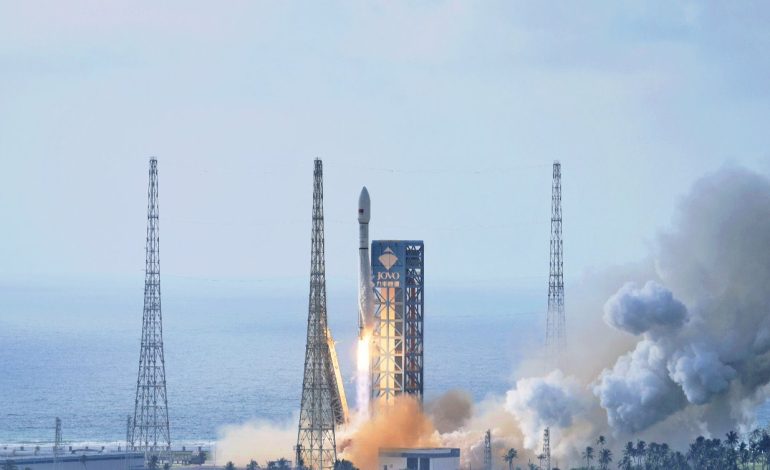
Chinese Long March-12 carrying internet-beaming satellites during its launch, on September 17, 2026. (Photo: Global Times)

New Delhi: China conducted two orbital launch missions from separate spaceports on Thursday, placing another batch of low-Earth-orbit internet satellites into space and deploying two commercial radar-imaging satellites designed for more frequent monitoring of changes on the Earth’s surface. The closely timed missions underline the growing breadth of China’s space programme, combining large-scale satellite constellation deployment with increasingly specialized commercial remote-sensing capabilities.
The first mission took place at 8.32am China Standard Time (6.02am IST) from the Hainan Commercial Spacecraft Launch Site, where a Long March-12 rocket successfully placed the 25th group of low-orbit internet satellites into their designated orbit. According to CASC and Chinese state media, it was the 667th flight of the Long March family, reflecting the exceptionally high launch tempo that has become a feature of China’s expanding space infrastructure.
The Long March-12 was developed by the Eighth Academy of CASC and is notable as China’s first single-core-stage rocket in the four-metre-diameter class. At about 62 metres long, the liquid-propellant launcher can carry at least six tonnes to a 700-kilometre sun-synchronous orbit and can use payload fairings of different diameters to accommodate single or multiple satellites.
The Hainan launch is significant beyond the individual payload because China is building a substantial low-orbit communications infrastructure in parallel with its established government space programmes. Repeated deployment missions such as this one provide the launch cadence needed to populate and eventually operate large constellations, placing commercial and state-backed launch services at the centre of the country’s emerging space ecosystem.
Just over two hours later, at 10.40am, a Kuaizhou-11 Y3 solid-propellant rocket lifted off from the Jiuquan Satellite Launch Center in north-west China and placed two satellites – Tianyi-51 and Tianyi-52 – into their planned orbits. Xinhua reported that the flight was the seventh mission of the Kuaizhou-11 and the 40th launch across the Kuaizhou rocket family.
The two spacecraft, identified as Tianyi-51, also known as Caiyun SAR01, and Tianyi-52, also known as Xinglianti Tianyuan YG01, form a commercial interferometric synthetic aperture radar, or InSAR, pair. Chinese space-industry reporting describes them as the first commercial medium-inclination InSAR satellites to be successfully placed in orbit, although that distinction is based on the developers’ and Chinese state-media description.
Their most important feature is the choice of a 55-degree medium-inclination orbit rather than the sun-synchronous orbits traditionally associated with many Earth-observation missions. In practical terms, the different orbital geometry is intended to make repeated observations of selected areas more frequent and to provide viewing angles that can complement conventional radar observations.
InSAR works by comparing radar observations of the same area taken at different times, allowing very small changes in the Earth’s surface to be detected. The developers say the new orbital arrangement can reduce the repeat-observation interval for interferometric monitoring from several days to about one day, with a further reduction to several hours envisaged as additional satellites are added to the network.
The system is also intended to improve the ability to measure deformation in three dimensions, addressing limitations in determining north-south movement with conventional InSAR approaches. Multi-angle observations are designed to reduce blind spots created by high-rise buildings, steep mountains and deep valleys, potentially making the system more useful in complex urban and mountainous environments.
Those capabilities have direct civil and infrastructure applications, particularly in a country exposed to landslides, subsidence and other forms of terrain deformation. The satellites are intended to support geological-disaster surveillance, identification of potentially unsafe buildings, inspection of hydropower installations and monitoring of major transport corridors, with the broader objective of providing more regular space-based data for both routine and emergency assessment.
The mission is also part of a much larger commercial ambition by Tianyi Space, which is reported to be working towards a 120-satellite high-performance SAR constellation. Such a network, if fully deployed, would shift commercial radar remote sensing towards higher revisit rates and potentially allow more continuous monitoring rather than relying primarily on individual satellite passes.
The Kuaizhou-11 itself is designed around a different requirement from the larger Long March-12. Developed by Kuaizhou Aerospace Space Technology, the solid-fuel launcher is intended to offer comparatively short preparation cycles, modest logistical requirements and lower launch costs, with a stated capacity of about one tonne to a 700-kilometre sun-synchronous orbit.
Taken together, Thursday’s launches illustrate two complementary strands of China’s space strategy: the rapid deployment of low-orbit communications infrastructure and the expansion of commercially operated Earth-observation capabilities. The significance lies not simply in putting six or more spacecraft into orbit in a single morning, but in the increasingly specialized launch and satellite architecture being assembled around them.
For India and other space-faring countries, the development is relevant to the wider Asian commercial-space landscape, where communications constellations, high-frequency Earth observation and lower-cost launch services are becoming increasingly important. China’s progress also highlights how commercial operators are moving beyond the traditional role of supplying individual spacecraft towards building integrated systems linking launch vehicles, satellite constellations, data processing and downstream applications.