



Typhoon Dolphin bears down on China’s east coast, forces mass evacuations and transport shutdowns
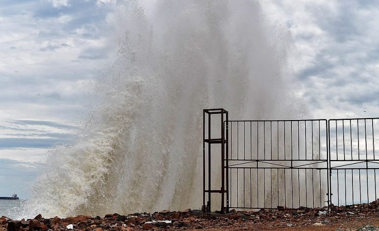
High waves hitting China’s east coast as Typhoon Dolphin approaches. (Photo: X/@CGTNOfficial)

New Delhi: Typhoon Dolphin, the 13th named storm of the 2026 Pacific season, has forced authorities across Shanghai, Zhejiang and Fujian into large-scale emergency measures as it closes in on China’s eastern seaboard. Ports, ferry routes, airports and tourist attractions across the region have been shut down as the storm – which battered Japan’s Okinawa and Amami islands earlier in the week – tracks towards landfall.
China’s meteorological authority upgraded its emergency response for the typhoon to Level III on Saturday and raised the storm warning from yellow to orange as it moved closer to the country’s eastern coast, according to Xinhua News Agency. By 10am on Saturday, Dolphin was positioned roughly 500 kilometres east of Wenzhou in Zhejiang province, carrying maximum sustained winds of 45 metres per second and classified as a strong typhoon, according to Wang Haiping, chief forecaster at the National Meteorological Centre in Beijing.
The storm had already left its mark further east. Dolphin briefly reached super typhoon strength, with winds exceeding 265kmph – equivalent to a Category 5 hurricane – as it swept past Japan’s Ryukyu Islands. Its passage through Okinawa injured five people and cut power to roughly 14,000 buildings before the storm turned towards the Chinese mainland.
Forecasters have described Dolphin’s track as remarkable. The storm formed west of the International Date Line and has travelled an unusually long distance towards China, and it is very rare for a system following such a track to make landfall at this intensity, said Dong Lin, chief forecaster at the National Meteorological Centre.
The typhoon is expected to make landfall along China’s eastern coast between late Sunday and early Monday, most likely somewhere between Zhoushan in Zhejiang and Fuding in Fujian. Once ashore, it is forecast to bring heavy rain to areas north of the landfall site as it weakens from typhoon to severe typhoon intensity.
Rainfall totals could be substantial. Parts of eastern Zhejiang could receive more than 600mm of rain, while wind and rain are expected to affect eastern China and Shanghai’s neighbouring provinces through August 12. The remnants of the storm are not expected to dissipate quietly, either: after crossing the coast, the system is forecast to merge with cold air and trigger a fresh spell of heavy rain over north and northeast China around the middle of the month.
Mass precautionary shutdowns
Zhejiang has taken the brunt of the precautionary shutdown. The province ordered the suspension of all port operations and passenger ferry services along its coast from 8am on Saturday, halted work at 193 water-related construction projects, and moved 474 construction vessels to sheltered waters.
Neighbouring Fujian has followed suit. By noon on Saturday, 40 passenger ferry routes along the Fujian coast had been suspended, along with 76 vessels taken out of service, while all 115 coastal water construction projects in the province were halted and 290 construction vessels moved to safety. The Fujian Maritime Safety Administration also imposed traffic controls at the northern and southern entrances of the Taiwan Strait – a route of considerable strategic sensitivity.
Shanghai, though slightly further from the storm’s projected path, is not taking chances. Pudong New Area is planning to relocate around 103,000 residents, while Chongming District has set up 378 temporary shelters for emergency use, according to the news outlet thepaper.cn. The city’s ferry services were suspended at 1.58pm on Saturday, CCTV News reported, citing the local ferry operator.
Air travel has been hit hard across the region. Ningbo Lishe International Airport announced it would suspend all flight operations from 11.30pm on Saturday through Sunday, with resumption to be decided based on the storm’s development. Beyond Ningbo, flights out of Wenzhou, Taizhou, Hangzhou and Shanghai have also been badly affected, and major Chinese carriers – including Air China, China Eastern, China Southern, Hainan Airlines, Spring Airlines and Juneyao Airlines – have issued fee waivers for passengers wishing to rebook or cancel.
Tourist sites, theme parks closed
The disruption has extended well beyond transport infrastructure. Zhejiang has suspended or postponed 23 cultural and tourism events, relocated 1,698 tourists and advised 364 tour groups to cancel their trips, while a total of 294 cultural and tourism venues and 230 high-risk tourism projects have been closed. All 37 coastal scenic areas in the province were shut from 6pm on Thursday, followed by 155 water-related tourist attractions from 6pm on Friday.
Even the region’s biggest theme parks are affected. Legoland Shanghai Resort will suspend operations from 6pm on Sunday, citing safety concerns, while Shanghai Disney Resort will close at 8pm the same day, with Disneytown shutting an hour later. Both resorts have indicated that further adjustments will depend on how the weather develops.
The scale of China’s response reflects lessons learned from previous storm seasons, when late evacuations and inadequate flood defences contributed to significant casualties and economic losses along the same stretch of coastline. This year’s pre-emptive shutdown of ports, construction sites and tourist facilities – often days ahead of landfall – points to a now well-rehearsed civil defence playbook, even as climate scientists continue to debate whether warming seas are producing storms that intensify more rapidly and travel further than in previous decades.