


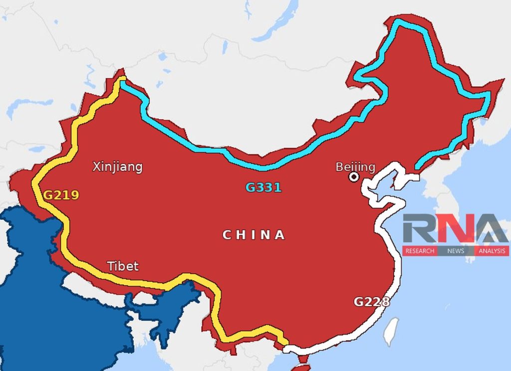
New Delhi: China plans to connect three national highways into an approximately 27,000-kilometre transport loop running along its land frontiers and eastern coastline by 2030. Promoted as an engine for regional development, tourism and trade, the network will also strengthen Beijing’s ability to move personnel and supplies through remote and strategically sensitive border regions.
The project, described by Chinese state media as the “golden outer ring”, will combine the G219 and G331 border highways with the G228 coastal route. The plan forms part of China’s 15th Five-Year Plan for 2026–2030 and was outlined at a government briefing on July 21 by the vice-minister of transport, Xu Chengguang.
Xu said the three highways would become important corridors for tourism, natural-resource development and what Beijing calls “stabilizing and strengthening” its border areas. China also intends to raise the completion rate of its principal integrated transport network from 91 per cent to 95 per cent by the end of the decade, according to a Xinhua report.
The announcement does not mean China will construct an entirely new 27,000-kilometre road from the ground up. Much of the network already exists, while Beijing plans to close missing links, replace vulnerable sections and upgrade about 7,400 kilometres during the five-year period, the People’s Daily reported.
Chinese transport authorities estimate that this construction and modernization programme will require around 370 billion yuan. The G219 and G331 are expected to reach at least China’s third-class highway standard, while the coastal G228 is to meet second-class standards or higher.
The G219, the component with the greatest direct relevance to India, is planned to stretch nearly 10,000 kilometres from Kanas in the Xinjiang Uygur autonomous region to Dongxing in Guangxi. It follows China’s western and southern frontiers through Xinjiang, Tibet and Yunnan, passing close to borders with countries including India, Pakistan, Nepal, Bhutan, Myanmar, Laos and Vietnam.
The northern arm, the approximately 9,200-kilometre G331, will connect Altay in Xinjiang with Dandong in Liaoning province, near the North Korean border. Passing through six provincial-level regions, it will run across China’s frontier with Central Asia, Mongolia and Russia before reaching the northeast.
The third arm, the G228, will extend about 7,400 kilometres from Dandong to Dongxing, following the mainland coastline through 10 provincial-level regions and several of China’s largest ports and industrial centres. Together, the three routes will create a continuous network linking China’s inland border crossings with its heavily industrialized seaboard.
One of the most technically demanding projects will be the G219 section between Zhaosu and Wensu in Xinjiang, where engineers are cutting through the Tianshan mountains. The project includes a 15.7-kilometre tunnel and is expected to reduce the road distance between Yining and Aksu from 1,710 kilometres to about 445 kilometres, according to Yicai Global.
Beijing’s stated economic rationale is substantial because many of the areas along the two border highways remain isolated, thinly populated and poorly connected with major markets. Better roads could reduce freight costs, attract tourism and investment, improve access to public services and connect mineral, agricultural and forestry-producing regions with ports and inland commercial centres.
The network is also intended to link more than 100 major border crossings with China’s principal coastal ports, helping integrate overland trade with Central and Southeast Asia and maritime routes. Chinese planners argue that this would turn peripheral regions that once functioned as transport dead ends into gateways for domestic commerce and cross-border trade.
However, roads running through contested or militarily sensitive territory inevitably possess a dual-use character, regardless of their civilian and commercial purposes. A connected and more resilient highway network would give the People’s Liberation Army additional options for moving troops, equipment, fuel and engineering resources between theatres while reducing dependence on a small number of vulnerable routes.
Why G219 matters to India
The strategic significance of G219 predates the latest project because its original Xinjiang-Tibet section passes through Aksai Chin, which India regards as part of the Union territory of Ladakh but China controls. Beijing constructed the road in the 1950s to secure a direct connection between Xinjiang and Tibet, and the discovery of that route became one of the factors that intensified the boundary dispute before the 1962 India-China war.
India maintains that China occupies approximately 38,000 square kilometres of its territory in Aksai Chin. New Delhi reiterated that position while protesting against a Chinese map depicting Aksai Chin and Arunachal Pradesh as Chinese territory.
Upgrading the G219 and integrating it with parallel roads, railways, airfields and feeder routes would improve China’s logistical flexibility across the Tibetan plateau and western Xinjiang. It could also enable faster reinforcement between sectors facing Ladakh, Uttarakhand, Sikkim and Arunachal Pradesh, although the highway itself remains only one part of a much larger Chinese infrastructure system.
The project must nevertheless overcome formidable engineering and environmental challenges, including high-altitude permafrost, earthquakes, landslides, deserts, forests and ecologically fragile Himalayan and coastal landscapes. Maintaining long and lightly used stretches through extreme weather could prove as difficult and expensive as building them.
China’s “golden outer ring” is therefore more accurately understood as the integration and modernization of three vast existing corridors than as a single new ring road. For India, its commercial objectives should not obscure the military mobility, redundancy and border-management advantages that an upgraded G219 could provide along an unresolved and occasionally volatile frontier.