


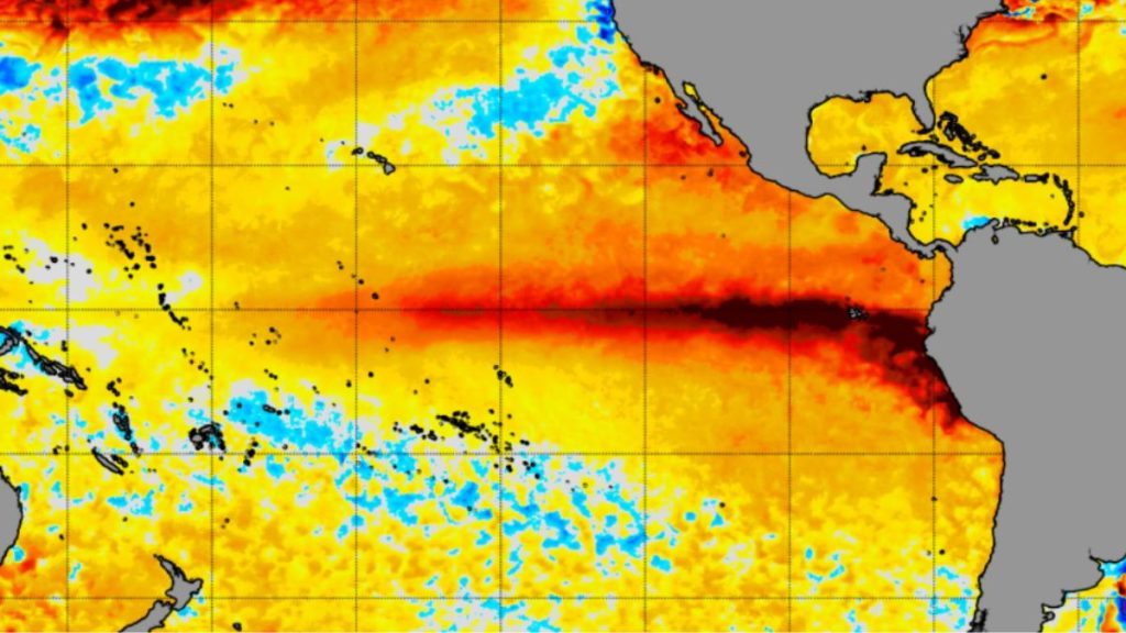
New Delhi: El Niño over the Pacific could become the strongest in more than a century, the UK’s Met Office said this week, warning that sea-surface temperatures in the key monitoring region could rise by more than 3°C. The warning lands as India’s own monsoon is already running behind schedule, with rainfall so far this season 12% below the long-period average, according to the India Meteorological Department (IMD).
The development is particularly significant for India because the southwest monsoon is already running below normal. With IMD expecting El Niño conditions to strengthen through the rest of the season, the focus is now on how the intensifying Pacific warming could shape rainfall over the remaining weeks of the monsoon.
What is happening over the Pacific
El Niño is the warm phase of the El Niño-Southern Oscillation, or ENSO, a natural ocean-atmosphere cycle centred on the tropical Pacific. Under El Niño conditions, unusually warm water spreads across the central and eastern equatorial Pacific, which alters atmospheric circulation and can shift rainfall patterns as far away as the Indian subcontinent.
The numbers explain why forecasters worldwide are watching closely. The US National Oceanic and Atmospheric Administration’s (NOAA) Climate Prediction Center said on August 13 that El Niño was strengthening, with more than a 90% chance of a very strong event during the northern hemisphere autumn and winter of 2026–27.
The strength of the warming is already evident in the data. The July Niño-3.4 index stood at +1.4°C, while sea-surface temperatures in the eastern equatorial Pacific were more than 2°C above normal, according to the Climate Prediction Center.
The scale of the warming is also reflected in the World Meteorological Organization’s latest forecast, which puts the average sea-surface temperature anomaly at about 2.9°C for August–October. The Met Office is projecting an even stronger signal, with Pacific temperatures potentially rising above 3°C, a level that would make this the strongest El Niño in more than a century, according to The Guardian.
IMD notes an important caveat here: there is no universally accepted scientific definition of a “super El Niño,” so the term should be treated as a descriptive label rather than an official classification.
India already starting from a deficit
The 2026 monsoon did not begin with much of a cushion. IMD’s first-stage forecast on April 13 projected seasonal rainfall at 92% of the long-period average, with an error margin of plus or minus 5%, and flagged that El Niño conditions could develop during the season.
That forecast was revised lower on May 29, when IMD put seasonal rainfall at 90% of the long-period average and said below-normal rainfall was most likely across the country, including over the Monsoon Core Zone, which covers much of India’s rain-fed agricultural belt.
The rainfall numbers since then show how the season has actually unfolded. Between June 1 and August 12, India received 486.2mm of rainfall against a normal of 552.6mm, a 12% deficit. But that national figure hides a sharper regional divide: east and northeast India were 26% below normal, northwest India 11% below normal, and south peninsular India 19% below normal, while central India was close to normal.
That unevenness matters because India’s agricultural exposure to the monsoon is regional, not simply national.
How El Niño affects India
El Niño’s effects on India work mainly through one channel: the monsoon. Everything else – water supply, farming, prices – follows from there.
It starts by weakening the monsoon’s engine. El Niño disrupts the atmospheric circulation that normally pulls moisture from the Indian Ocean towards the subcontinent, and IMD says this typically brings below-normal rainfall, more frequent dry spells and reduced reservoir inflows, according to its FAQ on ENSO and the Indian monsoon. This year, that mechanism is already visible in the 12% deficit recorded through August 12.
From there, it hits agriculture hardest, since nearly half of India’s farming depends on rain. Kharif crops – rice, cotton, oilseeds, pulses – are sown directly against the monsoon’s timing and spread, and this year’s sowing is already trailing last year’s pace by about 1.8%, with rice acreage alone down close to 16 lakh hectares as of August 7, according to a Press Information Bureau (PIB) update.
Weaker rainfall then strains water and power supply, since reduced reservoir inflows affect both irrigation for the following season and hydropower generation. IMD lists water resources and hydropower, alongside agriculture, among the sectors it monitors for ENSO-linked stress.
That, in turn, feeds into food prices, though the connection isn’t mechanical or immediate. Weaker harvests tighten supply of the crops most affected, which adds pressure to food inflation over the following months, well after the rainfall numbers themselves have been published.
But the effect isn’t uniform. El Niño doesn’t hit India as a single block, and this year’s regional divide – a 26% deficit in the northeast against a near-normal central India – shows exactly why. Nor does El Niño guarantee a weak monsoon on its own. Other systems, particularly a positive Indian Ocean Dipole (IOD), can partly offset its effect.
The Indian Ocean could still change the equation
That offsetting effect is exactly what remains unresolved for the rest of this season. A positive IOD, where the western Indian Ocean runs warmer than the eastern Indian Ocean, generally favours moisture transport towards India and can partially, or even substantially, counter El Niño’s weakening influence.
The current picture is uncertain. IMD’s July 31 forecast said the IOD was neutral and expected to stay that way through the rest of the season, though some international forecasting centres were pointing to the possibility of a positive IOD developing in September. That difference matters, since September still falls within India’s monsoon season. IMD has said it will issue its September rainfall forecast by the end of August.
What this means for Indian agriculture
The picture on the ground isn’t one of uniform damage. Some crops and regions have recovered as July rainfall improved, while others, like rice, remain behind last year’s sowing pace. Oilseed acreage, by contrast, was actually 5.19 lakh hectares higher than last year, which is why how rainfall is distributed through August and September matters more than the national average alone.
The government has built in some cushion against this uncertainty. The agriculture ministry said in May that 192 lakh quintals of seed were available against a kharif requirement of about 173 lakh quintals, along with a national reserve of 1.74 lakh quintals set aside for delayed rainfall, prolonged dry spells or resowing, according to a separate PIB release.
This matters beyond the farm
There is a temperature dimension worth flagging too. IMD’s August outlook expects above-normal maximum temperatures across most of the country, with its second-half monsoon forecast putting rainfall below 94% of the long-period average for August–September, compounding the stress on both crops and water supply.
The numbers worth watching now
Three figures will likely tell the story over the coming weeks. The monsoon deficit currently stands at 12% below the long-period average through August 12.
The remaining-season forecast puts rainfall below 94% of the long-period average for August–September, against a normal of 422.8mm for that period. And El Niño’s own strength, measured by NOAA’s Niño-3.4 index, stood at +1.4°C in July, with more than a 90% chance of a very strong event later this year.
El Niño does not determine India’s rainfall on its own. But in a year when the monsoon has already accumulated a deficit, its strengthening gives India another reason to watch the Pacific, and to watch the final weeks of its own monsoon even more closely.